Thursday, December 5, 2013

Banda Aceh, Indonesia

Since it is almost the nine year anniversary of the Indian Ocean Tsunami of 2004, I wanted to do a post from that part of the world.  While researching what is easily the most deadly event of the 2000s decade, the place I frequently read as being "hardest hit" was the city of Banda Aceh which is located near the northernmost point of Sumatra.  Out of the >230,000 people estimated killed by the tsunami, 160,000 were said to have been killed (or were missing) in or around the Banda Aceh area.  That's potentially 70% of the total amount of victims.

The before (1st image in gif) and after (2nd image in gif) give a pretty clear sense of the scale of damage.  From what I'm interpreting, it appears that the entire area contained in this image was inundated by the wave.  The silver lining is in the 3rd image of the gif.  After only four years (2009), the city looks much cleaner in aerial imagery, and reconstruction of the coastline seems to have taken place.  Still, the appearance of the coastline is now dramatically different from its pre-tsunami shape.

The gif below shows June 2004, January 2005 (1 month after tsunami), and February 2009 (~4 years after tsunami):


You can find it yourself on Google Earth using these coords:     5°33'30"N    95°17'00"E  

More info from sources referenced: Tsunami WikipediaBanda Aceh Wikipedia, Dec 2012 Article

Check back for more in two weeks! (Unless I decide to take a break for the Holidays. We'll see.)

Wednesday, November 20, 2013

Black River (Arkansas)

Up until now, every one of my entries had covered one specific location.  This is the first multi-location post I've made and that fact is sort of poking my OCD in the head with a pointy stick.  Instead of a single point with a single lat/long, I'm dealing with three points on a non-straight line and three lat/longs (specifically three confluences involving 4 rivers).  Not ONLY that, each separate location's gif cycles through a different number of images over unmatched lengths of time.  It is complete chaos as far as neatness and consistency go.

Unfortunately, the only alternatives would have been to split this post into three separate posts (at my biweekly schedule, this would take up over a month) OR to cut out two of the locations and just go with one of them (but that would make this feature seem much less special).

And we're all about special.

This is why this post is called Black River (Arkansas).  Each feature here occurs at a confluence with the Black River in Arkansas.  Starting upstream, this includes:
  • The Black River and the Current River at Pocahontas, AR
  • The Black River and the Spring River at Black Rock, AR
  • The Black River and the White River at Jacksonport, AR
At each confluence, the two rivers coming together show two distinct colors.  This isn't an uncommon occurrence considering many rivers travel through a variety of soils at different flow rates, pick up different run-off, and have different chemistries and biological features (all of which can change with the climate and seasons).  It only makes sense that the color of each river would be somewhat different based on all of these factors.  What I like about the Black River is the apparent misnomer.  Firstly, it is not some exceptionally dark river or anything.  I hear "Black River" and I expect this thing to look like a stream of crude oil.  Secondly, with such distinctly colored confluences, I think this river really should have been called the "Prismatic River" or the "Earthy Hues River"; really anything other than "Black River" would have been better.

It's been a while since I've written so much in one post.  I think most readers skip to the gifs right away, but if you've been reading all of this you must be quite the scholar and I thank you for hearing me out.

Black River and Current River:


Black River and Spring River:


Black River and White River:


You can find them yourself on Google Earth using these coords:

  • 36°15'10" N    90°54'45" W
  • 36°06'50" N    91°04'25" W
  • 35°38'20" N    91°19'20" W  

More info from: Wikipedia

Check back for more in two weeks!

Thursday, November 7, 2013

Karymsky Volcano, Russia

Karymsky: funny name, serious volcano.  Karymsky is a very active stratovolcano located on Russia's Kamchatka Peninsula.  The Global Volcanism Program calls it the most active volcano of Kamchatka's eastern volcanic zone and describes its eruptions as vulcanian or vulcanian-strombolianIn late April or early May the volcano burped out enough ash to leave a beautiful, black, ash fall on the snow-covered landscape.  Landsat 8 snapped a picture of the area around the volcano on May 20, 2013, and that image was subsequently featured on NASA's Earth Observatory website.

The following gif shows the Landsat 8 image from May 20th and a previous, snowless image (which Google Earth lists as April 9, 2013 though I'm not sure I believe that...)


For some great photos of Karymsky follow these links:

You can find it yourself on Google Earth using these coords:     54°03'N    159°25'E  

More info from sources referenced: WikipediaEarth Observatory, Global Volcanism Program

Check back for more in two weeks!

Wednesday, October 23, 2013

Yosemite National Park, California

On August 17th, a hunter's illegal fire went out of control and began burning through the area outside of Yosemite Valley.  As of the most recent update from InciWeb (October 18, 2013), the total area burned was at 1040 sq kilometers (402 sq miles) and the fire was 95% contained.  The total damage accumulated so far is over 127 million USD. This is over two months after the fire began. There were a few closures around Yosemite National Park but most of the Park was able to remain open.

Between drought, heat, and forest service budget cuts, this fire happened at a pretty bad time.  NASA's Earth Observatory followed the event through the Suomi research satellite and provided the images that I have produced into gif format below.

The following gif shows August 16, 2013 through September 3, 2013.  The green border near the center is the Yosemite National Park boundary:

The first week of the fire showed the greatest expansion.

Video of the fire from Yosemite NP's Youtube page:


You can find it yourself on Google Earth using these coords:     37°50' N 120°06' W  

More info from sources referenced: Wikipedia, InciWeb, Huffington Post, Earth Observatory

Check back in two weeks to explore a Russian Volcano!

Saturday, October 19, 2013

SPECIAL BLOG: Fun With Geographic Orientation

If you’ve ever been to an Outback Steakhouse you’ve probably seen an upside-down map of the world somewhere near the entrance of the building.  Outside of Outback Steakhouse, most maps you will ever see will have north at the top, south at the bottom, east to the right, and west to the left.  If you pull up any quadrangle map from the USGS, you’ll find it oriented north.  If you open Google Earth, the North Pole will be at the top of the screen.  If a GIS student turns in a map with West at the top of the page, he probably fails his assignment.  Whether they’re official or unspoken, the rules dictate that we orient our maps north.

Until recently, if you had wanted to see a map oriented in any way other than north, you could have rotated it, but you would have ended up with something that looked like this:

Img Credits: geology.com

With the map labels oriented north as well, our minds just see a sideways map and we try to tilt our heads or adjust the image in our brains.  However, with some digital applications, we can rotate a map to any direction and see the map labels oriented to that degree.  This makes the text readable but the map itself will look wildly foreign.

Texas oriented to the south:


Instead of wearing Oklahoma like a hat, Texas now sits on Oklahoma and uses New Mexico as a footrest while reclining on Louisiana.

Italy oriented to the south:


How eccentric does Italy seem?

Traverse City oriented to the south:


I love how all you have to do is turn Michigan upside down to render the names “Upper Peninsula” and “Lower Peninsula” useless.

Sea of Japan oriented to the south:


It’s pretty weird to see the word ”South” above the word “North” on the Korean Peninsula.  I'm sure this particular orientation is banned by Dear Leader.

Southern Florida oriented to the south:


If you use your imagination, you can pretend Cuba here is actually the edge of a large continent.

Lake Erie oriented to the west:


You could sail down the lake from Detroit to Buffalo.

Boston oriented to the east:


Cape Cod towers over all.

UAE oriented to the east:


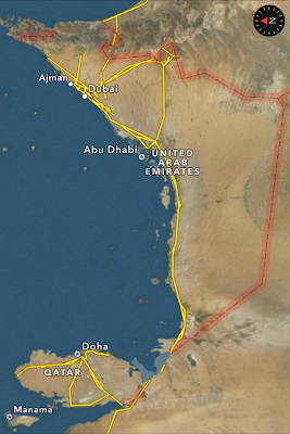
The coast here kind of looks like Western France.


Scandinavia oriented to the southwest:


It’s so askew!

In full disclosure, this is actually Apple Maps and not Google Earth.

Friday, October 11, 2013

Lakewood, Wisconsin

Well folks, I was caught off guard by the US Government shutdown and lost access to some of the websites I frequent for this blog.  I had planned on taking some data from NOAA for this post but unfortunately those pages are closed until the government gets back up and running.  I do have some limited information from wikipedia so I'll be using that.  Feel free to be skeptical of what you read here until I can come back and edit this post with the NOAA data.

From June 6-8 2007, a tornado outbreak occurred in the Northern Plains and Great Lakes regions.  On June 7, the largest tornado of the outbreak cut a path through Northeast Wisconsin as an EF3.  No one was killed and only a dozen buildings were damaged but the scar it left on Wisconsin would make you think otherwise.  From the imagery provided by Google Earth, a 40-mile-long (64 km) treeless path can be seen stretching linearly through the forest.  The path is close 3/4 of mile (1.2 km) wide at the widest point.  According to wikipedia, 14,000 acres (57 km sq) of forest were toppled by the tornado.

The following gif shows December 2005, September 2008, and November 2010:


Zoomed out for reference


You can find it yourself on Google Earth using these coords:     45°13'N  88°30'W  

More info from sources referenced: Wikipedia

Check back in two weeks to explore a giant wildfire!

Wednesday, September 25, 2013

Jackson, Mississippi

I'm a pretty big fan of oxbow lakes (and the process of their formation!)  Unfortunately, oxbow lakes probably don't have a lot of "fans" and probably don't even hold most folks' attention for more than a few minutes.  However, I'd like to argue that they really should.  Why?

1) They can happen in your lifetime!  Unlike mountain building, continental rifting, volcanic island-chain formation, and ice age cycles, oxbow lakes can easily form and change the physical geography of a place in a relatively short amount of time.  They share a category in this regard with things like glacial retreat and natural disasters (only the implications of a meander cutoff aren't as dooming, so there's another plus.)

2) They ignore the petty politics of geographical borders.  Thinking about splitting from your neighbors?  Why not use the nearby stream as the geographical border between your newly divided lands?  That's easier than having to put up a fence, right?  Think again!  That stream might decide to move at some point!  What happens when that fancy apple orchard growing inside the meander gets cut off and ends up on your neighbor's side of the stream?  Who owns your precious apples now???

3) They're all about taking shortcuts.  Who doesn't love a shortcut?  Point A and Point B will briefly be a little closer together before the continuous erosion of cut banks extend the remaining meanders outwards.

4) They influenced my decision to keep this blog going.  Last time I blogged about a meander cutoff it spread all over Google+ and Twitter and was shared by a number of other science and non-science bloggers.  To this day, that blog entry is my most popular – being viewed almost 100x more than my next highest viewed entry.  I'm extremely proud of this, and it was one of the reasons I kept this blog going.  Oxbow lakes saved my life blog!

That lengthy introduction was to lead up to this new oxbow lake blog entry!  The occurrence is just south of Jackson, Mississippi on the Pearl River and looks great in this imagery:


Here's a good example of county boundaries (shown as the thin green line and probably designated over a century ago) that were ignored by the Pearl River:


You can find it yourself on Google Earth using these coordinates:     32°11'20"N  90°12'00"W  

More info: Wikipedia

Check back in two weeks to see a large scar in Wisconsin!

Wednesday, September 11, 2013

Aq Qala, Iran

Unfortunately, I don't have a whole lot of information to associate with this imagery.  I was browsing Google Earth with my free time and exploring northern Iran when I came across a flood just outside of the city of Aq Qala in the Golestan province.  I tried looking up "March 2012 Golestan floods" and other related search terms but couldn't find anything in particular that detailed the extent of the flooding.  If you happen to find anything, feel free to leave a comment below.

What is most notable about this image to me is the extent of flooding in the low-lying farms south of the main river channel.  You can see how the flood waters travelled up a small tributary stream that connects to the river in the northeast portion of the image.

The following gif shows June 2003, September 2007, October 2012, and March 2012:


You can find it yourself on Google Earth using these coords:     37°00'N  54°30'E  

More info from sources referenced: Wikipedia

Check back in two weeks to explore another oxbow lake formation in the Deep South!

Wednesday, August 28, 2013

West, Texas

The town of West, Texas (which is actually on the east side of Texas but not quite in "East Texas") was in the news on April 17th, 2013 after a massive explosion occurred in the town.  The fertilizer plant that had been on fire most of the day exploded when the 540,000 pounds of ammonium nitrate inside the building ignited.  Many buildings in the town suffered substantial damage as a result and the following investigations revealed a number of violations at the plant.  It also registered as a 2.1 on the Richter scale which, you can see on a seismograph and check out at the USGS site.


The following gif shows a before image from October, 2012 and an after image from April 18, 2013 (one day after the blast):


You can find it yourself on Google Earth using these coords:     31°49'N  97°05'W  

More info from sources referenced: Wikipedia

Check back in two weeks to head to Iran.

Thursday, August 15, 2013

Moore, Oklahoma

On May 20, 2013 an EF5 tornado cut through Moore, Oklahoma.  With 23 fatalities, it was the deadliest twister since the Joplin, Missouri Tornado in May 2011.  It stayed on the ground for 39 minutes and travelled 17 miles with peak winds hitting 210mph (~340km/h).

Here is a wide-view where the debris and destruction path can be seen as the faint tan line that runs just south of the "Moore" label:


When seen up close in Google Earth, I was able to trace the more obvious parts of the path from one end to the other:

The tornado path extends farther southwest, but the trail is not as obvious where the tornado was still weak


This is Briarwood Elementary School where the tornado had just previously reached EF5 status before leveling the building:


After Briarwood Elementary, the tornado continued through a neighborhood where it reached its peak winds of 200-210 mph and caused extreme damage:


The tornado continued east and arrived as an EF4 at Plaza Towers Elementary where 7 children were killed:


The tornado crossed highway I-35 and continued through southeastern Moore and eventually began to dissipate in the sparsely populated fields east of town.  It left an apocalyptic scene that haunted the media the next few days.

In late 2008, I had returned home to Houston a few weeks after Hurricane Ike and remember seeing the blue tarps covering damaged rooftops as the plane descended into the city.  These blue tarps cover many roofs in Moore, Oklahoma as well:


You can find it yourself on Google Earth using these coords:     35°19'28"N  97°30'30"W  

More info from sources referenced: Wikipedia

Check back in two weeks to see the devastation of a large explosion.

Tuesday, August 6, 2013

Gale Crater Region, Mars

It's been an entire year now since Curiosity landed on Mars!  On August 6, 2012 Curiosity made one of the most astounding landings ever in order to begin its mission of determining Mars's former climate.  During that landing, the parachute slowed the capsule down from about 1,300mph (2080km/h) to 220mph (354 km/h) before the powered descent and sky crane took over for the last bit of the descent.  The University of Arizona's HiRISE camera (Hi Resolution Imaging Science Experiment) on the Mars Reconnaissance Orbiter was able to capture the capsule (containing the rover) parachuting towards the Martian surface.  The gif below superimposes that image to a previous image taken by the same camera.  The resolutions and angle of the images were slightly different so the before and after gif isn't perfect.  I did my best, painstakingly trying to align the two so I don't want to hear any complaints.

The animation below shows about a months difference in time with the parachute image taken on August 6, 2012:


Here is a much higher resolution view of the parachute and capsule:
Source: University of Arizona HiRISE

Video from YouTube of the landing (with increased frames per second):


You can find it yourself on Google Earth by switching to Google Mars and using the toolbar on the left for the Curiosity Mission.

More info from sources referenced: Wikipedia MSL, HiRISE

Thursday, August 1, 2013

Gila National Forest, New Mexico

I've noticed Google Earth tends to not have a lot of imagery with snow.  In the same sense that clouds in the imagery can hinder the view, snow-cover is probably considered a less-than-desirable condition.  When I do happen to come across an image with snow, I have to flip back and forth between the snow view and snowless view; it just looks way too cool!  I was trying to look around for some wildfire imagery from nearby this area when I stumbled across this beautiful summer-to-winter view not far from Whitewater Baldy Mountain.

The animation below shows 1.5 years from August 2011 to February 2013:


You can find it yourself on Google Earth using these coords:     33°18'N  108°35'W

Check back in two weeks to see a terrifying scar in Oklahoma.

Thursday, July 18, 2013

Devils Lake, North Dakota

Devils Lake is an endorheic lake in North Dakota.  Endorheic is the term for a lake or drainage basin with no outlet to an external body of water.  Because the lake is endorheic, it can vary wildly in water levels in a period of a few years or decades.  The water level in the lake is currently at about 1454 ft which is up 53 ft from the 1401 ft level in the 1940s.  At 1446 ft, the lake overflows into nearby Stump Lake.  This occurred at the turn of the century.  If the water level reaches 1458 ft, the water will naturally flow into the Sheyenne River (this is only 4 ft higher than the current level).  In the last decade, a man-made channel was constructed to connect the lake to the Sheyenne river, allowing relief during floods.  Some of the reasons why Devils Lake has risen to high levels in recent times include increased rain during the 1990s and the altering of land for farming that in-turn increases the runoff rate.


The drainage basin around the lake covers roughly 3,800 square miles (9,840 square km) as shown in the image.  The Devils Lake drainage basin is shown in purple.  Image source: savethesheyenne.org

Historical Lake Level from USGS


The animation below shows 22 years from July 1990 to April 2012:


You can find it yourself on Google Earth using these coords:     48°N  99°W  (Simple enough?)

More info from sources referenced: Wikipedia, USGS

Check back in two weeks to see a drastic summer/winter change!

Sunday, July 14, 2013

Book Review: The Power of Place by Harm de Blij

During my last semester at university, I took a World Regional Geography class that turned out to be the best decision of my life.  Not only did it become one of my favorite classes I'd ever taken and introduced me to a terrific professor who is still my friend today, it provided me with Harm de Blij's Realms, Regions, and Concepts textbook (15th ed).  In the last two years I have worn that textbook down to shambles, reigniting my interests in all aspects of geography by flipping through its pages.  It currently sits on my coffee table where I can peruse it at will.

Image from amazon.com
As it happens, that's not the book I'm going to discuss here (as much as I love it).  I was hungry for more of Harm de Blij's work and did a quick search at my library for any books of his that they currently held.  The Power of Place: Geography, Destiny, and Globalization's Rough Landscape was the book I discovered there and boy was it a great read.

The book opens with an introduction into the three distinctive groups that de Blij refers to throughout.  He names these groups the Globals, Locals, and Mobals.  The Globals are the folks that are born with the greatest diversity when it comes to opportunity.  They are the people who live in developed nations and have the most flexibility with how they live their lives.  They have a high standard of living and can move throughout the developed world with ease.  The other end of the spectrum features the Locals.  These are the people who de Blij points out will likely live out their lives and die not far from where they were born.  Their level of education, their profession, wealth, language, and religion will  go mostly unchanged from generation to generation.  The middle group, the Mobals, are those that are breaking away from the life of the Local and moving to become Globals.  They are facing all varieties of barriers in order to find a place among the developed world.

The author mostly focuses on the struggles that the Locals and Mobals endure.  He divides each struggle into its own chapter featuring topics such as: Language, Religion, Health, Hazards, Borders, and Gender.  In each chapter, he describes what causes imbalances in each issue and how these imbalances have affected particular societies.  He draws many examples from the time of Apartheid in South Africa where most of these issues factored into the problems that South African Locals and Mobals experienced there.
A solid 10

A final chapter discusses closing the gaps between Locals, Mobals, and Globals.  Harm de Blij leaves the reader with some thoughts about religious extremism, gender inequality, border control, and more that will need to be addressed for change to occur.  The underlying idea of a "flat world" for the Globals and a "rough terrain" for the Mobals and Locals resonate today through presentations like those done by Hans Rosling at TED Talks.

I give the book a two-thumbs-up recommendation, a solid 10 out of 10, a blue ribbon, etc.  It's a great book for any geography buff and provides a spatial perspective to today's current events.

If you take my advice and want to check the book out for yourself, here is the link to the book on Amazon and Goodreads where you can read more reviews.

Next Thursday the blog will start back up with the regular updates. 

Thursday, May 23, 2013

Charlevoix, Michigan

Due to a combination of recent hot and dry conditions in the Great Lakes area as well as limited snowmelt during the 2011 and 2012 winters, Lake Michigan-Huron reached all-time low water levels during 2013.

As the lake level approached almost 1 meter (~3 ft) below average, Fisherman's Island off the coast of Charlevoix, Michigan (in Fisherman's Island State Park) gained a narrow connection to the mainland.  The addition of this little land bridge means the island is now technically a peninsula.

The animation below shows 18 years from April 1994 to April 2012:


The reduction in water levels has exposed rocks and fossils all over the Northwestern Michigan coastline.  If you're a collector, get out there now!  I've found some great halysites, hexagonaria, brachiopods, gastropods, and pelecypods in nearby Traverse Bay.  DO NOT COLLECT IN STATE/NATIONAL PARKS though (you can get fined for that).

You can find it yourself on Google Earth using these coords:     45°17'20"N     85°21'45"W

Check back in two weeks to read a book review by one of my favorite geographers!

Thursday, May 9, 2013

Millau, Fance

From 2001 to the end of 2004, the Millau Viaduct was built in Southern France across the Tarn River Valley.  It is currently the tallest bridge (from the base to the top of the tallest pillar) in the world at 343 meters (1125 feet).  While I lack sufficient funding to go out and see it myself, Google Earth provides an impressive look at it:

2003: Before the bridge, but the bases of the columns are in place


2008: The bridge casting an impressive shadow.


Looking west using the 3D Buildings tool.


You can find it yourself on Google Earth using these coords:     44°05'N     03°01'E

More info: Millau Viaduct Wikipedia

NEW!!!: I've added a map feature to my blog near the top of the page where you can use Google Maps to see a spatial view of all my blog post locations.  Nifty right?

Check back in two weeks to see an island become a peninsula.

Thursday, January 24, 2013

Breezy Point, New York


Two weeks ago I posted about Hurricane Sandy's impact on New Jersey and the destruction it caused there through storm surge, waves, and wind.  Today I'll be showing images of Breezy Point, NY where the hurricane caused a different problem: Fire.

Like my last post, this story is really nothing new to those of us living in the USA.  Nevertheless, the devastation looks somewhat more revealing from above where the burned out homes look like a scar through the town.  

The animation below shows June 17, 2010 and November 3, 2012:


You can find it yourself on Google Earth using these coords:     40°33'28"N     73°55'05"W

More info: Jeff Master's Wunderblog during the month of October

NEW!!!: I've added a map feature to my blog near the top of the page where you can use Google Maps to see a spatial view of all my blog post locations.  Nifty right?

Check back in two weeks to see one of the most impressive road bridges in the world.

Thursday, January 10, 2013

Seaside Heights, New Jersey


Hurricane Sandy (or Superstorm Sandy as many have been calling it) made its landfall on New Jersey in late October of 2012.  While I doubt many of you reading this managed to not hear about this event, let me give you a brief summary anyway:

THIS HAPPENED
image credit: NASA

While there have been many stronger hurricanes both barometrically and velocity-wise (Wilma, Gilbert) and more lethal (Katrina, Mitch), Hurricane Sandy covered an exceptionally large area belonging to an exceptionally large & dense population.  Combine that with the fact that this area rarely receives a direct hurricane strike and voilá, you get the most talked about meteorological event of 2012 (at least in the USA).

Even without being the most powerful, destructive, or lethal hurricane of all time, Sandy was still a cruel beast.  The storm surges and wind damage certainly did a number on the Jersey Shore.  That brings me to Seaside Heights, NJ where Casino Pier seems to have misplaced one of its roller coasters.

The animation below shows September 20, 2010 and November 3, 2012:


Also note the reduction of sand on the beach.  I imagine that most of that will likely end up being rebuilt by the state during the next year or two in order to sustain the summertime tourists.

You can find it yourself on Google Earth using these coords:     39°56'33"N     74°04'07"W

More info: Jeff Master's Wunderblog during the month of October

NEW!!!: I've added a map feature to my blog near the top of the page where you can use Google Maps to see a spatial view of all my blog post locations.  Nifty right?

Check back in two weeks to see one more before and after from 2012's most talked about hurricane.