Wednesday, August 28, 2013

West, Texas

The town of West, Texas (which is actually on the east side of Texas but not quite in "East Texas") was in the news on April 17th, 2013 after a massive explosion occurred in the town.  The fertilizer plant that had been on fire most of the day exploded when the 540,000 pounds of ammonium nitrate inside the building ignited.  Many buildings in the town suffered substantial damage as a result and the following investigations revealed a number of violations at the plant.  It also registered as a 2.1 on the Richter scale which, you can see on a seismograph and check out at the USGS site.


The following gif shows a before image from October, 2012 and an after image from April 18, 2013 (one day after the blast):


You can find it yourself on Google Earth using these coords:     31°49'N  97°05'W  

More info from sources referenced: Wikipedia

Check back in two weeks to head to Iran.

Thursday, August 15, 2013

Moore, Oklahoma

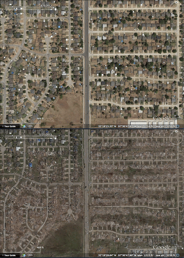
On May 20, 2013 an EF5 tornado cut through Moore, Oklahoma.  With 23 fatalities, it was the deadliest twister since the Joplin, Missouri Tornado in May 2011.  It stayed on the ground for 39 minutes and travelled 17 miles with peak winds hitting 210mph (~340km/h).

Here is a wide-view where the debris and destruction path can be seen as the faint tan line that runs just south of the "Moore" label:


When seen up close in Google Earth, I was able to trace the more obvious parts of the path from one end to the other:

The tornado path extends farther southwest, but the trail is not as obvious where the tornado was still weak


This is Briarwood Elementary School where the tornado had just previously reached EF5 status before leveling the building:


After Briarwood Elementary, the tornado continued through a neighborhood where it reached its peak winds of 200-210 mph and caused extreme damage:


The tornado continued east and arrived as an EF4 at Plaza Towers Elementary where 7 children were killed:


The tornado crossed highway I-35 and continued through southeastern Moore and eventually began to dissipate in the sparsely populated fields east of town.  It left an apocalyptic scene that haunted the media the next few days.

In late 2008, I had returned home to Houston a few weeks after Hurricane Ike and remember seeing the blue tarps covering damaged rooftops as the plane descended into the city.  These blue tarps cover many roofs in Moore, Oklahoma as well:


You can find it yourself on Google Earth using these coords:     35°19'28"N  97°30'30"W  

More info from sources referenced: Wikipedia

Check back in two weeks to see the devastation of a large explosion.

Tuesday, August 6, 2013

Gale Crater Region, Mars

It's been an entire year now since Curiosity landed on Mars!  On August 6, 2012 Curiosity made one of the most astounding landings ever in order to begin its mission of determining Mars's former climate.  During that landing, the parachute slowed the capsule down from about 1,300mph (2080km/h) to 220mph (354 km/h) before the powered descent and sky crane took over for the last bit of the descent.  The University of Arizona's HiRISE camera (Hi Resolution Imaging Science Experiment) on the Mars Reconnaissance Orbiter was able to capture the capsule (containing the rover) parachuting towards the Martian surface.  The gif below superimposes that image to a previous image taken by the same camera.  The resolutions and angle of the images were slightly different so the before and after gif isn't perfect.  I did my best, painstakingly trying to align the two so I don't want to hear any complaints.

The animation below shows about a months difference in time with the parachute image taken on August 6, 2012:


Here is a much higher resolution view of the parachute and capsule:
Source: University of Arizona HiRISE

Video from YouTube of the landing (with increased frames per second):


You can find it yourself on Google Earth by switching to Google Mars and using the toolbar on the left for the Curiosity Mission.

More info from sources referenced: Wikipedia MSL, HiRISE

Thursday, August 1, 2013

Gila National Forest, New Mexico

I've noticed Google Earth tends to not have a lot of imagery with snow.  In the same sense that clouds in the imagery can hinder the view, snow-cover is probably considered a less-than-desirable condition.  When I do happen to come across an image with snow, I have to flip back and forth between the snow view and snowless view; it just looks way too cool!  I was trying to look around for some wildfire imagery from nearby this area when I stumbled across this beautiful summer-to-winter view not far from Whitewater Baldy Mountain.

The animation below shows 1.5 years from August 2011 to February 2013:


You can find it yourself on Google Earth using these coords:     33°18'N  108°35'W

Check back in two weeks to see a terrifying scar in Oklahoma.