Showing posts with label Feature: Flood. Show all posts

Wednesday, September 25, 2013

Jackson, Mississippi

I'm a pretty big fan of oxbow lakes (and the process of their formation!)  Unfortunately, oxbow lakes probably don't have a lot of "fans" and probably don't even hold most folks' attention for more than a few minutes.  However, I'd like to argue that they really should.  Why?

1) They can happen in your lifetime!  Unlike mountain building, continental rifting, volcanic island-chain formation, and ice age cycles, oxbow lakes can easily form and change the physical geography of a place in a relatively short amount of time.  They share a category in this regard with things like glacial retreat and natural disasters (only the implications of a meander cutoff aren't as dooming, so there's another plus.)

2) They ignore the petty politics of geographical borders.  Thinking about splitting from your neighbors?  Why not use the nearby stream as the geographical border between your newly divided lands?  That's easier than having to put up a fence, right?  Think again!  That stream might decide to move at some point!  What happens when that fancy apple orchard growing inside the meander gets cut off and ends up on your neighbor's side of the stream?  Who owns your precious apples now???

3) They're all about taking shortcuts.  Who doesn't love a shortcut?  Point A and Point B will briefly be a little closer together before the continuous erosion of cut banks extend the remaining meanders outwards.

4) They influenced my decision to keep this blog going.  Last time I blogged about a meander cutoff it spread all over Google+ and Twitter and was shared by a number of other science and non-science bloggers.  To this day, that blog entry is my most popular – being viewed almost 100x more than my next highest viewed entry.  I'm extremely proud of this, and it was one of the reasons I kept this blog going.  Oxbow lakes saved my life blog!

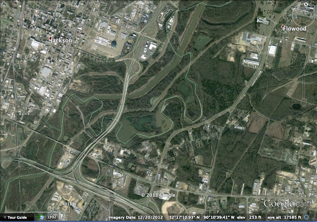
That lengthy introduction was to lead up to this new oxbow lake blog entry!  The occurrence is just south of Jackson, Mississippi on the Pearl River and looks great in this imagery:


Here's a good example of county boundaries (shown as the thin green line and probably designated over a century ago) that were ignored by the Pearl River:


You can find it yourself on Google Earth using these coordinates:     32°11'20"N  90°12'00"W  

More info: Wikipedia

Check back in two weeks to see a large scar in Wisconsin!

Wednesday, September 11, 2013

Aq Qala, Iran

Unfortunately, I don't have a whole lot of information to associate with this imagery.  I was browsing Google Earth with my free time and exploring northern Iran when I came across a flood just outside of the city of Aq Qala in the Golestan province.  I tried looking up "March 2012 Golestan floods" and other related search terms but couldn't find anything in particular that detailed the extent of the flooding.  If you happen to find anything, feel free to leave a comment below.

What is most notable about this image to me is the extent of flooding in the low-lying farms south of the main river channel.  You can see how the flood waters travelled up a small tributary stream that connects to the river in the northeast portion of the image.

The following gif shows June 2003, September 2007, October 2012, and March 2012:


You can find it yourself on Google Earth using these coords:     37°00'N  54°30'E  

More info from sources referenced: Wikipedia

Check back in two weeks to explore another oxbow lake formation in the Deep South!

Thursday, July 18, 2013

Devils Lake, North Dakota

Devils Lake is an endorheic lake in North Dakota.  Endorheic is the term for a lake or drainage basin with no outlet to an external body of water.  Because the lake is endorheic, it can vary wildly in water levels in a period of a few years or decades.  The water level in the lake is currently at about 1454 ft which is up 53 ft from the 1401 ft level in the 1940s.  At 1446 ft, the lake overflows into nearby Stump Lake.  This occurred at the turn of the century.  If the water level reaches 1458 ft, the water will naturally flow into the Sheyenne River (this is only 4 ft higher than the current level).  In the last decade, a man-made channel was constructed to connect the lake to the Sheyenne river, allowing relief during floods.  Some of the reasons why Devils Lake has risen to high levels in recent times include increased rain during the 1990s and the altering of land for farming that in-turn increases the runoff rate.


The drainage basin around the lake covers roughly 3,800 square miles (9,840 square km) as shown in the image.  The Devils Lake drainage basin is shown in purple.  Image source: savethesheyenne.org

Historical Lake Level from USGS


The animation below shows 22 years from July 1990 to April 2012:


You can find it yourself on Google Earth using these coords:     48°N  99°W  (Simple enough?)

More info from sources referenced: Wikipedia, USGS

Check back in two weeks to see a drastic summer/winter change!

Thursday, March 1, 2012

Carhué, Argentina

During the early 20th century, Villa Lago Epecuén, Argentina was a popular destination for tourists because of the many spas that the town had to offer.  The town resides by an inland salt lake where many people believed the water had healing properties.  On November 10, 1985, Lake Epecuén began to overflow its banks into the town.  By 1993, some parts of the town had been submerged by ten meters.  In 1989, nearby town, Carhué, was dry and above ground so people began to relocate there.

By 2009, a dry spell greatly receded the waters of the lake.  This helped expose the ruins of the old town.  The photos of the ruins are fascinating,  I highly recommend turning on the photos layer on Google Earth and exploring this place yourselves!  It is quite an interesting place.


January 3, 2003


February 28, 2011


February 28, 2011 (From a Wider View)


February 28, 2011 (Zoomed In- Villa Lago Epecuén)


February 28, 2011 (Zoomed In- Area West of Carhué)


You can find it yourself on Google Earth using these coords:      37°09'41.11"S     62°46'08.44"W

I highly recommend that last link to the Geochemists!

Check back next week to see something I've been trying to find on Google Earth for a very long time!

Thursday, September 15, 2011

Lesterville, Missouri

Taum Sauk is (was?) a reservoir in the St. Francois mountain region in southern Missouri Ozarks.  On December 14, 2005, the wall of the reservoir failed and released one billion gallons of water in 12 minutes. The resulting surge of water tore a path through the mountain leaving it bare down to the bedrock making geologists everywhere very very happy.


August, 2005


August, 2007


You can find it yourself on Google Earth using these coords:     37°32'07.79"N     90°49'06.80"W


Check back next week to see unstoppable mud.