Showing posts with label *Natural Disaster. Show all posts

Thursday, December 5, 2013

Banda Aceh, Indonesia

Since it is almost the nine year anniversary of the Indian Ocean Tsunami of 2004, I wanted to do a post from that part of the world.  While researching what is easily the most deadly event of the 2000s decade, the place I frequently read as being "hardest hit" was the city of Banda Aceh which is located near the northernmost point of Sumatra.  Out of the >230,000 people estimated killed by the tsunami, 160,000 were said to have been killed (or were missing) in or around the Banda Aceh area.  That's potentially 70% of the total amount of victims.

The before (1st image in gif) and after (2nd image in gif) give a pretty clear sense of the scale of damage.  From what I'm interpreting, it appears that the entire area contained in this image was inundated by the wave.  The silver lining is in the 3rd image of the gif.  After only four years (2009), the city looks much cleaner in aerial imagery, and reconstruction of the coastline seems to have taken place.  Still, the appearance of the coastline is now dramatically different from its pre-tsunami shape.

The gif below shows June 2004, January 2005 (1 month after tsunami), and February 2009 (~4 years after tsunami):


You can find it yourself on Google Earth using these coords:     5°33'30"N    95°17'00"E  

More info from sources referenced: Tsunami Wikipedia, Banda Aceh Wikipedia, Dec 2012 Article

Check back for more in two weeks! (Unless I decide to take a break for the Holidays. We'll see.)

Wednesday, October 23, 2013

Yosemite National Park, California

On August 17th, a hunter's illegal fire went out of control and began burning through the area outside of Yosemite Valley.  As of the most recent update from InciWeb (October 18, 2013), the total area burned was at 1040 sq kilometers (402 sq miles) and the fire was 95% contained.  The total damage accumulated so far is over 127 million USD. This is over two months after the fire began. There were a few closures around Yosemite National Park but most of the Park was able to remain open.

Between drought, heat, and forest service budget cuts, this fire happened at a pretty bad time.  NASA's Earth Observatory followed the event through the Suomi research satellite and provided the images that I have produced into gif format below.

The following gif shows August 16, 2013 through September 3, 2013.  The green border near the center is the Yosemite National Park boundary:

The first week of the fire showed the greatest expansion.

Video of the fire from Yosemite NP's Youtube page:


You can find it yourself on Google Earth using these coords:     37°50' N 120°06' W  

More info from sources referenced: Wikipedia, InciWeb, Huffington Post, Earth Observatory

Check back in two weeks to explore a Russian Volcano!

Wednesday, September 11, 2013

Aq Qala, Iran

Unfortunately, I don't have a whole lot of information to associate with this imagery.  I was browsing Google Earth with my free time and exploring northern Iran when I came across a flood just outside of the city of Aq Qala in the Golestan province.  I tried looking up "March 2012 Golestan floods" and other related search terms but couldn't find anything in particular that detailed the extent of the flooding.  If you happen to find anything, feel free to leave a comment below.

What is most notable about this image to me is the extent of flooding in the low-lying farms south of the main river channel.  You can see how the flood waters travelled up a small tributary stream that connects to the river in the northeast portion of the image.

The following gif shows June 2003, September 2007, October 2012, and March 2012:


You can find it yourself on Google Earth using these coords:     37°00'N  54°30'E  

More info from sources referenced: Wikipedia

Check back in two weeks to explore another oxbow lake formation in the Deep South!

Thursday, August 15, 2013

Moore, Oklahoma

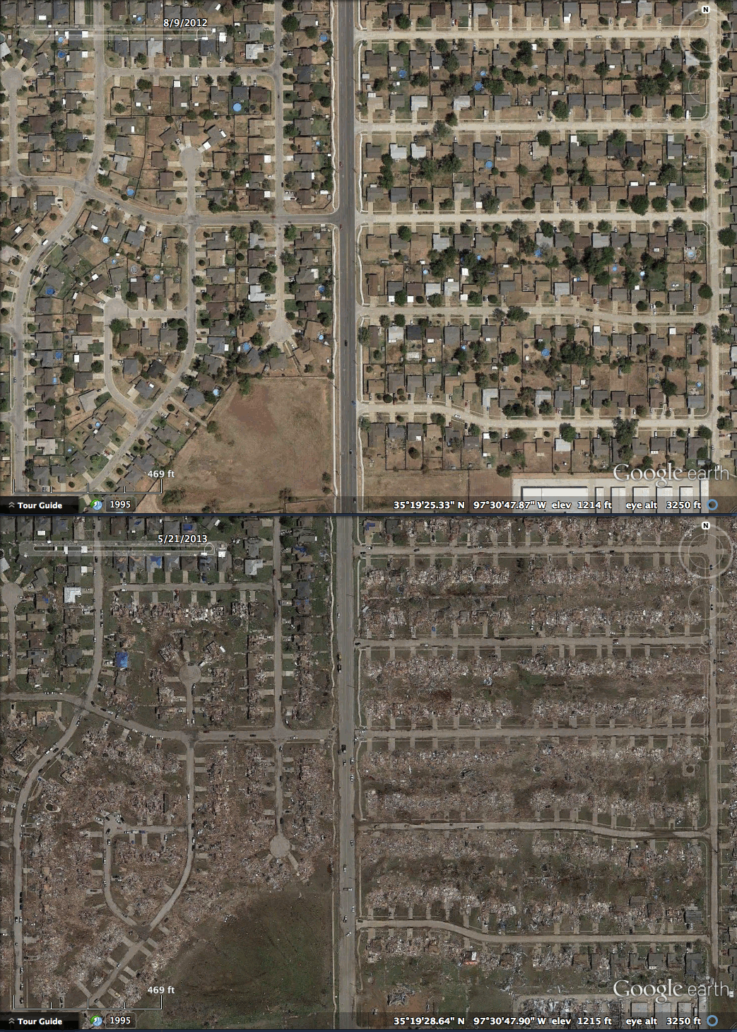
On May 20, 2013 an EF5 tornado cut through Moore, Oklahoma.  With 23 fatalities, it was the deadliest twister since the Joplin, Missouri Tornado in May 2011.  It stayed on the ground for 39 minutes and travelled 17 miles with peak winds hitting 210mph (~340km/h).

Here is a wide-view where the debris and destruction path can be seen as the faint tan line that runs just south of the "Moore" label:


When seen up close in Google Earth, I was able to trace the more obvious parts of the path from one end to the other:

The tornado path extends farther southwest, but the trail is not as obvious where the tornado was still weak


This is Briarwood Elementary School where the tornado had just previously reached EF5 status before leveling the building:


After Briarwood Elementary, the tornado continued through a neighborhood where it reached its peak winds of 200-210 mph and caused extreme damage:


The tornado continued east and arrived as an EF4 at Plaza Towers Elementary where 7 children were killed:


The tornado crossed highway I-35 and continued through southeastern Moore and eventually began to dissipate in the sparsely populated fields east of town.  It left an apocalyptic scene that haunted the media the next few days.

In late 2008, I had returned home to Houston a few weeks after Hurricane Ike and remember seeing the blue tarps covering damaged rooftops as the plane descended into the city.  These blue tarps cover many roofs in Moore, Oklahoma as well:


You can find it yourself on Google Earth using these coords:     35°19'28"N  97°30'30"W  

More info from sources referenced: Wikipedia

Check back in two weeks to see the devastation of a large explosion.

Thursday, January 24, 2013

Breezy Point, New York


Two weeks ago I posted about Hurricane Sandy's impact on New Jersey and the destruction it caused there through storm surge, waves, and wind.  Today I'll be showing images of Breezy Point, NY where the hurricane caused a different problem: Fire.

Like my last post, this story is really nothing new to those of us living in the USA.  Nevertheless, the devastation looks somewhat more revealing from above where the burned out homes look like a scar through the town.  

The animation below shows June 17, 2010 and November 3, 2012:


You can find it yourself on Google Earth using these coords:     40°33'28"N     73°55'05"W

More info: Jeff Master's Wunderblog during the month of October

NEW!!!: I've added a map feature to my blog near the top of the page where you can use Google Maps to see a spatial view of all my blog post locations.  Nifty right?

Check back in two weeks to see one of the most impressive road bridges in the world.

Thursday, January 10, 2013

Seaside Heights, New Jersey


Hurricane Sandy (or Superstorm Sandy as many have been calling it) made its landfall on New Jersey in late October of 2012.  While I doubt many of you reading this managed to not hear about this event, let me give you a brief summary anyway:

THIS HAPPENED
image credit: NASA

While there have been many stronger hurricanes both barometrically and velocity-wise (Wilma, Gilbert) and more lethal (Katrina, Mitch), Hurricane Sandy covered an exceptionally large area belonging to an exceptionally large & dense population.  Combine that with the fact that this area rarely receives a direct hurricane strike and voilá, you get the most talked about meteorological event of 2012 (at least in the USA).

Even without being the most powerful, destructive, or lethal hurricane of all time, Sandy was still a cruel beast.  The storm surges and wind damage certainly did a number on the Jersey Shore.  That brings me to Seaside Heights, NJ where Casino Pier seems to have misplaced one of its roller coasters.

The animation below shows September 20, 2010 and November 3, 2012:


Also note the reduction of sand on the beach.  I imagine that most of that will likely end up being rebuilt by the state during the next year or two in order to sustain the summertime tourists.

You can find it yourself on Google Earth using these coords:     39°56'33"N     74°04'07"W

More info: Jeff Master's Wunderblog during the month of October

NEW!!!: I've added a map feature to my blog near the top of the page where you can use Google Maps to see a spatial view of all my blog post locations.  Nifty right?

Check back in two weeks to see one more before and after from 2012's most talked about hurricane.

Thursday, February 23, 2012

Yogyakarta, Indonesia


Mount Merapi is an active stratovolcano located on the island of Java.  It erupts fairly frequently, with larger eruptions happening every 10 to 15 years.  The most recent eruption was in 2010 and killed 353 people.  However, in 2006 another eruption occurred.  This eruption was less powerful but it was captured pretty well on satellite imagery.  The eruptions began around the end of April and lasted through May.  Below are before, during, and after images. 

(facts and figures from wikipedia)


May 12, 2006
Wait for it...

May 25, 2006
Kablammo!  Gasses and ash abound!


September 10, 2006
Check out those new lava flows!


You can find it yourself on Google Earth using these coords:      07°32'41.22"S    110°26'41.90"E

Check back next week to see the town that returned from the depths.

Thursday, January 26, 2012

Christchurch, New Zealand

EDIT: I had the wrong dates on the images.  They are now correct.

On February 2nd, 2011, Christchurch, New Zealand was struck by an magnitude 6.3 aftershock from a quake in the October 2010.  Despite the 2010 quake being a magnitude 7.1, the February 2011 aftershock was rated a IX on the Mercalli intensity scale, causing heavy damage and liquefaction across the city.

These images take some scanning, but if you look at the top left of the "before" image, you should see the shadow of the large bell tower on the Christchurch Cathedral.  On the "after" image, notice that the bell tower has collapsed.  If you look at the bottom right, you'll see the CTV building that collapsed during the quake, killing 115 people.

February 14, 2011


February 25, 2011


You can find it yourself on Google Earth using these coords:      43°31'54.62"S     172°38'21.66"E

Check back next week to see my blog's first entry on a landslide!

Thursday, January 19, 2012

Burnet, Texas


If you've been following this blog, you've most likely realized by now that I do a lot of Texas posts.  Well, being a native Texan, I've spent a good chunk of time looking around Texas on Google Earth and following Texas news so I feel like I can always find good material there.  Currently, with the fires and extreme drought this past year, I've been waiting for images from this summer and fall to make their way into public availability.  These past two months have really given me a lot to work with so I may have multiple Texas posts.  That being said, I'll try not to overload y'all with Texas imagery.

With the drought being slightly alleviated but still ongoing, Lake levels have been falling all over the state.  Some lakes more than others have really been affected.  Lake Buchanan is one in particular that has fallen significantly.  This graph from lakesonline.com shows the levels for the 2011 and 2012.

After that especially steep summer drop, the lake has leveled off around 988 ft. 

I thought I'd try and provide topo maps for some of my posts from now on so here's the topo for Lake Buchanan followed by the Google Earth imagery.

TOPO


January 31, 2008


October 17, 2011


You can find it yourself on Google Earth using these coords:     30°49'25.35"N     98°24'35.90"W

Check back next week to see the effects of an earthquake in a large, southern-hemisphere city.

Thursday, January 12, 2012

Bastrop, Texas (II)


Man, I've been looking forward to this post for a while.  I wanted to do this back in November but was limited by available imagery.  However,  imagery became available in December so I finally got what I wanted and am proud to present to you:

The before and after of the Bastrop County Complex Wildfire!

So when this fire first broke out,  my attention was caught immediately because Bastrop State Park is one of my favorite parks in Texas.  A bad combination of drought, heat, and extreme winds helped this fire quickly became the most destructive in Texas history.  According to Wikipedia, 1,645 homes were burned across over 34,000 acres and two people were killed.  Just looking at this picture from Wikipedia's page on the event gives an idea of the magnitude of this fire:

"Oh, hello Mr. Apocalypse. ...So you vacation in Bastrop too?"


I decided to see if those clouds were tall enough to register on the Doppler RADAR and low and behold, I was able to save this gif:

That's a roughly 4-hour span where at least three smoke plumes can be seen southeast of Austin.  Two other fire plumes from other fires can be seen north-northwest of Houston.


March 31, 2011


September 7, 2011
You'll all be happy to know that LUECKE is untouched.


You can find it yourself on Google Earth using these coords:      30°06'45.25"N     97°13'43.59"W

Check back next week to see the effects on a lake during extreme drought.

Thursday, November 24, 2011

Port-au-Prince, Haiti


This post marks my final piece of a three-post-series special for Thanksgiving.  This post, as well as the previous posts, will remind us what we have to be thankful for this Thanksgiving.


This post also happens to be my final post for 2011.  I'm taking the month of December off in order to enjoy my holidays, contact graduate programs, and find a ton of new blog material.  Keep sharing, and commenting though, I'll still be on and off!  See y'all on January 5th, 2012!

The 7.0 magnitude Haiti Earthquake of January 2010 was one of the biggest disasters of the 21st century.  The Haitian government estimated the death toll at 316,000 which would make it the third largest earthquake death toll in history.  Because of Haiti's poor building codes and a general lack of decent infrastructure, the damage was very widespread and severe.  Humanitarian aid came from many different countries though and worked hard to get medical supplies, food and drinking water, and clean up crews in.  The country is still rebuilding and still in need of many kinds of aid.  As many of my readers are in developed nations and countries that would recover from disaster much more quickly than Haiti, it is crucial to remember to be thankful.  Thankful that we live in countries that can get food, medicine, and drinking water to areas of need in a matter of hours. 

December 22, 2007


January 16, 2010
That's the partially collapsed National Palace after the earthquake.


You can find it yourself on Google Earth using these coords:       18°32'35.34"N     72°20'19.26"W

Check back January 5th, 2012 for ...???

Thursday, November 17, 2011

Soma, Japan

This post marks my second piece of a three-post-series special for Thanksgiving.  This post, as well as the previous and my next post, will remind us what we have to be thankful for this Thanksgiving season.

I was actually in a hospital recovery room after having a bone tumor removed from my leg when I saw this on the news.  Of every major event so far in my 22-year lifetime that I was mature enough to observe and understand, this definitely had the biggest impact on me.  I had seen footage of the even deadlier Indian Ocean tsunami back in 2004, but the footage that came from the March 11, 2011 tsunami in Japan was incredible.  The 9.0 earthquake that occurred off the coast of Japan was the most powerful ever recorded in the country.  The resulting damage was incredibly widespread as entire towns and prefectures were leveled.
However, the people of Japan are a very hardy, very tight community and they began rescue operations and rebuilding immediately with the help of many foreign nations.  We should all remember that disasters can strike virtually anywhere, even in the most advanced nations.  During these times, we should all be thankful for the help and support that the citizens and governments around the world can give to each other during these times.

September 20, 2010


March 12, 2011


You can find it yourself on Google Earth using these coords:       37°49'49.00"N     140°57'22.02"E

Check back next week to see one of the worst earthquakes of the western hemisphere.

Thursday, October 20, 2011

Greensburg, Kansas

On the night of May 4th, 2007, Greensburg Kansas (population 1600 at the time) was leveled by an EF5 tornado.  Ninety-five percent of the town was destroyed and 11 people lost their lives.  It was the first tornado to be given a classification of "5" on the Enhanced Fujita scale went into effect earlier that year.  The town has since been rebuilt into a "green town", running mostly on wind turbines.

August 2, 2006


May 6, 2007


RADAR:


You can find it yourself on Google Earth using these coords:      37°36'10.07"N     99°17'33.41"W

Check back next week to see beach erosion.

Thursday, September 29, 2011

New Orleans, Louisiana

Hurricane Katrina's landfall on New Orleans in 2005, to this day, is still considered the most costly disaster in U.S. history.  The staggering $133,800,000,000 price tag of it's damages is over three times the amount that Hurricane Andrew caused in 1992.  The death toll was roughly 1200 people, with even more deaths due to indirect effects of the hurricane.  The most damaging and deadly aspect of this storm however was the broken levee that inundated the Ninth Ward.


August 16, 2005


August 30, 2005


September 20, 2005


Landfall NEXRAD Loop:


You can find it yourself on Google Earth using these coords:      29°58'16.64"N    90°00'58.35"W

Check back next week to see a protest caught on satellite image.

Thursday, August 25, 2011

Tuscaloosa, Alabama

During the April 25-28th 2011 Super Outbreak, a series of tornados moved through the Southeastern United States. On April 27th, one of those tornados went through the heart of Tuscaloosa, Alabama as an EF4.  The path of destruction can easily be seen on satellite as an eerie brown line trending Northeast through the suburbs.

October, 2010


April, 2011


You can find it yourself on Google Earth using these coords:   33°11'42.87"N    87°32'03.62"W


Check back next week to see what you do with a neighborhood built on a toxic waste dump.