Showing posts with label Feature: Tornado. Show all posts

Friday, October 11, 2013

Lakewood, Wisconsin

Well folks, I was caught off guard by the US Government shutdown and lost access to some of the websites I frequent for this blog.  I had planned on taking some data from NOAA for this post but unfortunately those pages are closed until the government gets back up and running.  I do have some limited information from wikipedia so I'll be using that.  Feel free to be skeptical of what you read here until I can come back and edit this post with the NOAA data.

From June 6-8 2007, a tornado outbreak occurred in the Northern Plains and Great Lakes regions.  On June 7, the largest tornado of the outbreak cut a path through Northeast Wisconsin as an EF3.  No one was killed and only a dozen buildings were damaged but the scar it left on Wisconsin would make you think otherwise.  From the imagery provided by Google Earth, a 40-mile-long (64 km) treeless path can be seen stretching linearly through the forest.  The path is close 3/4 of mile (1.2 km) wide at the widest point.  According to wikipedia, 14,000 acres (57 km sq) of forest were toppled by the tornado.

The following gif shows December 2005, September 2008, and November 2010:


Zoomed out for reference


You can find it yourself on Google Earth using these coords:     45°13'N  88°30'W  

More info from sources referenced: Wikipedia

Check back in two weeks to explore a giant wildfire!

Thursday, August 15, 2013

Moore, Oklahoma

On May 20, 2013 an EF5 tornado cut through Moore, Oklahoma.  With 23 fatalities, it was the deadliest twister since the Joplin, Missouri Tornado in May 2011.  It stayed on the ground for 39 minutes and travelled 17 miles with peak winds hitting 210mph (~340km/h).

Here is a wide-view where the debris and destruction path can be seen as the faint tan line that runs just south of the "Moore" label:


When seen up close in Google Earth, I was able to trace the more obvious parts of the path from one end to the other:

The tornado path extends farther southwest, but the trail is not as obvious where the tornado was still weak


This is Briarwood Elementary School where the tornado had just previously reached EF5 status before leveling the building:


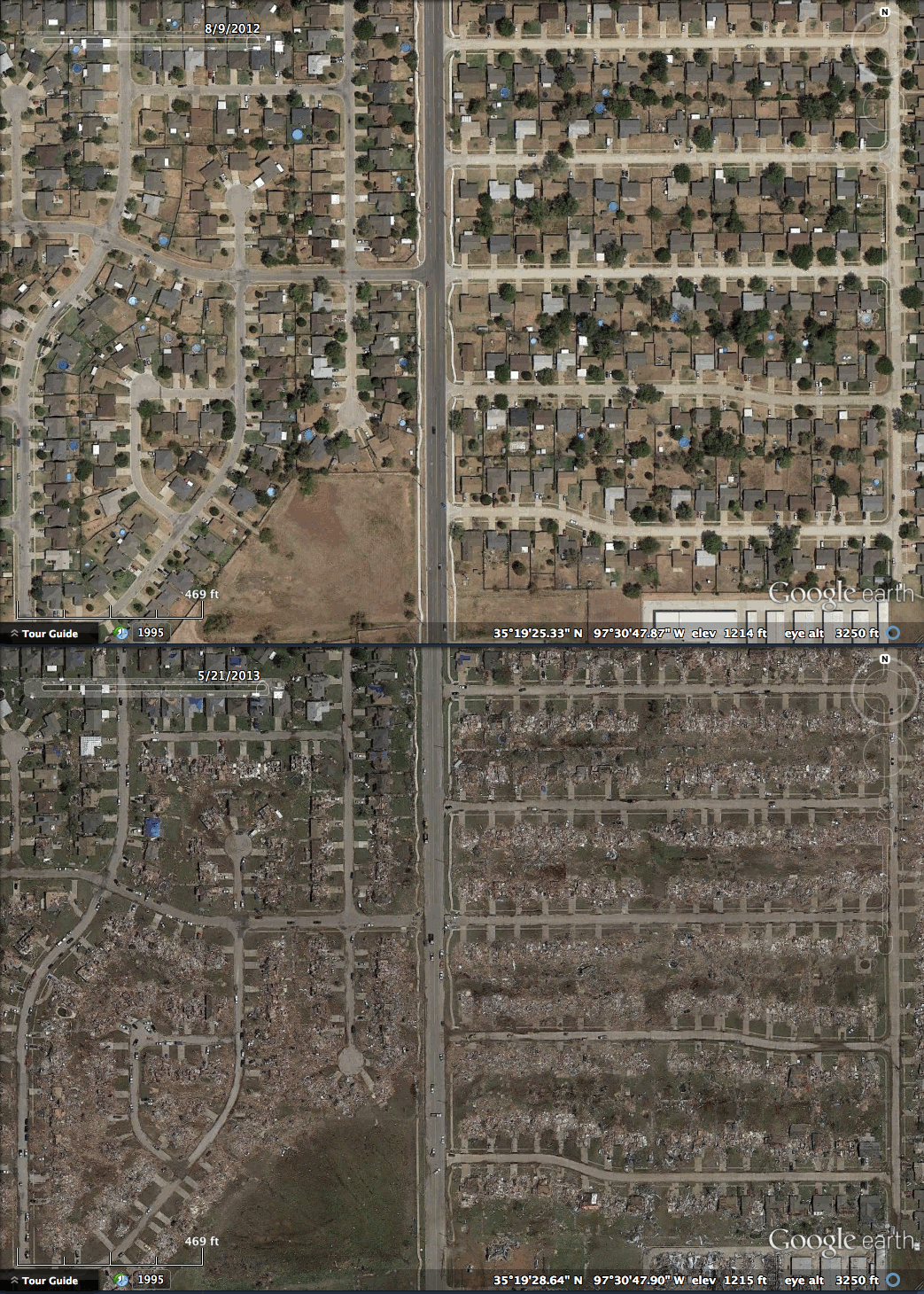
After Briarwood Elementary, the tornado continued through a neighborhood where it reached its peak winds of 200-210 mph and caused extreme damage:


The tornado continued east and arrived as an EF4 at Plaza Towers Elementary where 7 children were killed:


The tornado crossed highway I-35 and continued through southeastern Moore and eventually began to dissipate in the sparsely populated fields east of town.  It left an apocalyptic scene that haunted the media the next few days.

In late 2008, I had returned home to Houston a few weeks after Hurricane Ike and remember seeing the blue tarps covering damaged rooftops as the plane descended into the city.  These blue tarps cover many roofs in Moore, Oklahoma as well:


You can find it yourself on Google Earth using these coords:     35°19'28"N  97°30'30"W  

More info from sources referenced: Wikipedia

Check back in two weeks to see the devastation of a large explosion.

Thursday, October 20, 2011

Greensburg, Kansas

On the night of May 4th, 2007, Greensburg Kansas (population 1600 at the time) was leveled by an EF5 tornado.  Ninety-five percent of the town was destroyed and 11 people lost their lives.  It was the first tornado to be given a classification of "5" on the Enhanced Fujita scale went into effect earlier that year.  The town has since been rebuilt into a "green town", running mostly on wind turbines.

August 2, 2006


May 6, 2007


RADAR:


You can find it yourself on Google Earth using these coords:      37°36'10.07"N     99°17'33.41"W

Check back next week to see beach erosion.

Thursday, August 25, 2011

Tuscaloosa, Alabama

During the April 25-28th 2011 Super Outbreak, a series of tornados moved through the Southeastern United States. On April 27th, one of those tornados went through the heart of Tuscaloosa, Alabama as an EF4.  The path of destruction can easily be seen on satellite as an eerie brown line trending Northeast through the suburbs.

October, 2010


April, 2011


You can find it yourself on Google Earth using these coords:   33°11'42.87"N    87°32'03.62"W


Check back next week to see what you do with a neighborhood built on a toxic waste dump.